Linked Open Data Developments - What's in for UNGEGN and its Experts?
The webinar is the second in the UNGEGN webinar series, which generally seek to increase awareness on the use and benefits of geographical names standardization, and specifically focus on current topics relevant to advancing the implementation of UNGEGN's Strategic Plan and Programme of Work 2021-2029. This webinar provided an overview on the most relevant challenges and opportunities associated with linked open data (LOD) development, particularly given that LOD is another stage in the evolution of data management methodologies which the UNGEGN community needs to consider, to facilitate widespread use of standardized geographical names.
It is hoped that the webinar will encourage collaborations between national names authorities and LOD practitioners and that they will continue to share national case studies to demonstrate the benefits of standardized geographical names provided as LOD.
The webinar was attended by a global audience of over 100 persons, from national names authorities, national mapping agencies and universities.
Mr. Pier-Giorgio Zaccheddu of the Federal Agency for Cartography and Geodesy in Germany, and Convenor of the UNGEGN Working Group on Geographical Names Data Management moderated the webinar. The Chair of UNGEGN, Pierre Jaillard, France and Director of UNSD, Stefan Schweinfest delivered opening remarks. The first presentation, delivered by Henrik Askjer, University of Bergen, Norway, briefly introduced LOD from a historical perspective, its main requirements (e.g., a definition of vocabularies, commonly agreed ontologies, etc.) and its potential in the context of disseminating geographical names data as LOD. This was followed by national LOD implementations cases from the Netherlands and Germany. The examples presented shared the benefits of LOD implementation, the methodology, architecture, and software that were used, in addition to the challenges experienced and solutions adopted. The closing presentation was delivered by Peder Gammeltoft, Scientific Manager, Norwegian Language Collections, University of Bergen, Norway and Chair of the UNGEGN Working Group on Publicity and Funding. He gave an overall summary of the challenges, opportunities and benefits of LOD. This was followed by a lively discussion session, which pointed to next steps which included the need for experts to work together to create vocabularies and ontologies.
The comments shared in the webinar chat, such as
"Thanks for the wonderful webinar!!! Looking forward for the next.",
"Thank you very much for all speakers. nice talk, it is really new knowledge for me."
"Thank you for an excellent and useful webinar."
"Thank you for this informative webinar."
"Excellent presentations and discussion, thanks!"
- Introduction From "Adam and Eve, Henrik Askjer, Norway
- Kadaster Knowledge Graph (KKG), Alexandra Rowland, Netherlands
- National LOD implementation or projects - Germany-, Falk Würriehausen, Germany
- Linked Open Dat Are we blessed or cursed? Peder Gammeltoft, Norway
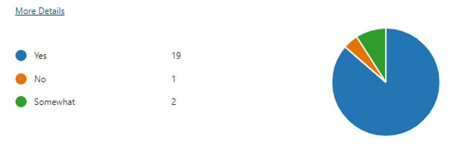
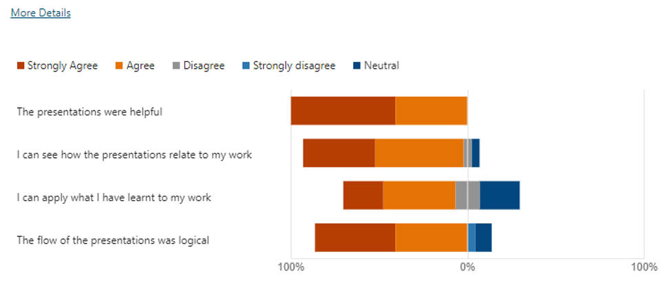
To improve the quality, content and delivery of its awareness raising and capacity building webinars, UNGEGN sought feedback from participants. The following are extracts from the results based on 22 responses.
- Learning more about developing use of LOD
- Seeing practical uses of RDF and linked open data.
- Get basic information on Open Linked Data
- Get information about Linked Open Data, particularly related to geographical names. I wanted to see some examples of applications of these new concepts, notions, and technologies
6. Rate your agreement with the following statements
- Meetings
- Mandate
- Resolutions
- Divisions
- Working Groups
- Bureau and Convenors
- Liaison Officers
- Resources
- Events
- Links
- Contact
- UNGEGN/UN-GGIM Collaborative Project
Access the approved document here
To receive the UNGEGN bulletin, click to complete the form