|
3. Plane rectangular coordinate systems - B) horizontal datums |
||
|
Ellipsoids have varying position
and orientations. An ellipsoid is positioned and oriented
with respect to the local mean sea level (or Geoid) by adopting
a latitude ( Several hundred local horizontal
datums exist in the world. The reason is obvious: Different
local ellipsoids with varying position and orientation had
to be adopted to best fit the local mean sea level in different
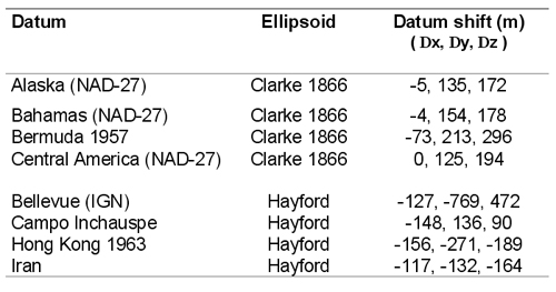
countries or regions. For examples of local horizontal datums with their underlying ellipsoid and difference in position (datum shift) with respect to WGS84, see image below.
Source: Knippers, 2002
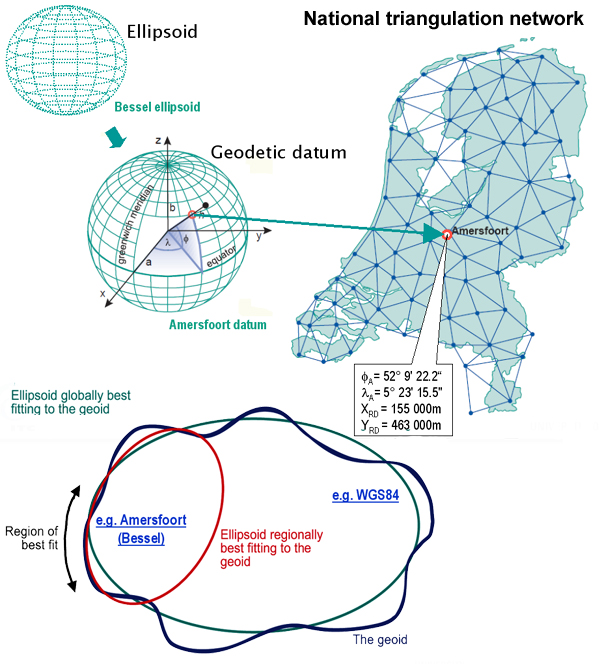
In the above case, the local horizontal
datum is realized through a so-called triangulation
network (or survey network). Such a network consists of monumented
points forming a network of triangular mesh element (figure
below). The angles in each triangle are measured in addition
to at least one side of a triangle; the fundamental point is
also a point in the triangulation network. The angle measurements
and the adopted coordinates of the fundamental point are then
used to derive geographic (or geodetic) coordinates
With increasing demands for global
surveying activities are underway to establish global reference
surfaces. The motivation is to make geodetic results mutually
comparable and to provide coherent results also to other disciplines
like astronomy and geophysics. The most important global (or geocentric) spatial reference system for the GIS community is the International Terrestrial Reference System (ITRS). It is a three-dimensional coordinate system with a well-defined origin (the centre of mass of the Earth) and three orthogonal coordinate axes (X,Y,Z). The Z-axis points towards a mean Earth north pole. The X-axis is oriented towards a mean Greenwich meridian and is orthogonal to the Z-axis. The Y-axis completes the righthanded reference coordinate system. The ITRS is realized through the International Terrestrial Reference Frame (ITRF), a distributed set of ground control stations that measure their position continuously using GPS. The trend is to use the ITRF everywhere
in the world for reasons of global compatibility. The World
Geodetic System of 1984 (WGS84) datum has been refined on several
occasions and is now aligned with the ITRF to within a few centimetres
worldwide. The Global Positioning System (GPS) uses the WGS84
as its reference system.
|
||
|
|
|
Home | Self study : Reference sytems | Contents | Intro | 1.Graticule / topographic grid | 2.Projection Systems (a/b/c/d) | 3.Plane rectangular coordinate systems (a/b) | 4.Coordinate transfor-mations | 5.Satellite-based positioning (a/b) |