|
2. Projection systems - C) Choosing a map projection |
||
|
The cartographer's task is to ensure that the right type of projection is used for any particular map. A well chosen map projection takes care that scale distortions remain within certain limits and that map properties match to the purpose of the map. In theory, the selection of a map projection for a particular area can be made on the basis of:
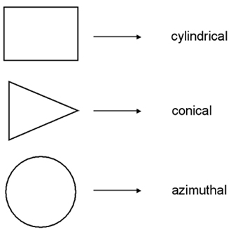
Ad 1) Ideally, the general
shape of the mapping area should match with the
distortion pattern of a specific projection (see figure below).
Ad 2) The choice of the aspect of a map projection depends largely on the location (and orientation) of the geographic area to be mapped. Optimal is when the projection centre coincides with centre of the area, or when the projection plane is located along the main axis of the area to be mapped.
Map projections with a conformal distortion property represent angles and local shapes correctly, but as the region becomes larger, they show considerable area distortions. An example is the Mercator projection. Although Greenland is only one-eighth the size of South America, Greenland appears to be larger on the Mercator projection. Maps used for the measurement of angles (e.g. aeronautical charts, topographic maps) often make use of a conformal map projection. Map projections with a equal-area distortion property on the other hand, represent areas correctly, but as the region becomes larger, it shows considerable distortions of angles and consequently shapes. Maps which are to be used for measuring areas (e.g. distribution maps) often make use of an equal-area map projection. The equidistant distortion property is achievable only to a limited degree. That is, true distances can be shown only from one or two points to any other point on the map or in certain directions. If a map is true to scale along the meridians (i.e. no distortion in North-South direction) we say that the map is equidistant along the meridians (e.g. the equidistant cylindrical projection in the figure below). If a map is true to scale along all parallels we say the map is equidistant along the parallels (i.e. no distortion in East-West direction). Maps which require correct distances measured from the centre of the map to any point (e.g. air-route, radio or seismic maps) or maps which require reasonable area and angle distortions (several thematic maps) often make use of an equidistant map projection In summary, the ideal map projection for any country would either be an azimuthal, cylindrical, or conic projection, depending on the shape of the area, with a secant projection plane located along the main axis of the country or the area of interest. The selected distortion property depends largely on the purpose of the map. |
||
|
|
|
Home | Self study : Reference sytems | Contents | Intro | 1.Graticule / topographic grid | 2.Projection Systems (a/b/c/d) | 3.Plane rectangular coordinate systems (a/b) | 4.Coordinate transfor-mations | 5.Satellite-based positioning (a/b) |