| 3)
II) Ordering geogr. space - E) Future objects in reclaimed
areas |
|
|
Giving names to future objects in reclaimed areas (polders or
newly opened up areas such as in the tropical forests of Brazil
or Indonesia.
E1. Names in reclaimed polder areas
For new polders, reclaimed from the sea in the
Netherlands, names were adapted that referred to former settlements
that disappeared into the sea through storms and inundations
in the Middle Ages, taking account of changes in spelling that
reflect changes in pronunciation of the language and language
development since the Middle Ages. In figure below, in the Noordoostpolder
area, reclaimed in the 1940s, the name
Emmeloord refers to the village named
Emeloirt ( lost to the sea in 1650).
Bant refers to a village Bantega, inundated in 1700.
Marknesse has been named after a village Marcnesse or
Marenesse, a village that according to the chronicles once was
situated between the islands Urk and Schokland.
Creil has either been named after a sand bank in the
former Zuiderzee at Staveren, or after the Creiler Woud (forest).
Espel used to be a village name as well, once situated
east of Urk. It also occurs under the names Espelbergh and Espelo.
Kraggenburg derived its name from the former port in
the mouth of the IJssel river; the lighthouse of this port,
formerly situated at the end of a pier, is now part of the new
polder.
Luttelgeest was named after a village once situated next
to Kuinre.
Nagele refers to the name of a bank on which fishermen
tore their nets, as this was the place of the inundated ruins
of the village Nagele (on old maps Naghele or Nakala) located
once between Urk and Schokland lag.
Rutten is derived from the name Ruthne, a village located
north of Urk in the 14th century.
Tollebeek used to be a village close to Urk, before it
disappeared into the sea.
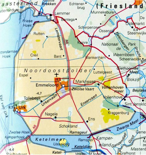
Names in an area newly reclaimed
from the sea
(Noordoostpolder, the Netherlands)
Other examples of language planning
E2)Language planning in transmigrasi projects, Indonesia
In Indonesia, the surplus agrarian population
of Java is resettled in less densely inhabited islands, like
Sumatra, Borneo, Celebes or New Guinea. This supervised migration
process is termed 'transmigrasi' locally. Here is a text that
shows some considerations for naming the new settlements: in
the Lampung area in Southern Sumatra) that had to be cleared
first in the dense tropical forests (Benoit and Pain, 1989)
:
"The present-day Kecamatan of Trimurjo
bears witness to this heroic past. In 1935, 'Kolonisatie' was
implemented; the program was so successful that the Japanese,
who were seeking any means of supplying their troops, decided
to continue it after the Dutch Indies surrendered on March 9,
1942. Toponymy has provided a grasp of the environment, the
difficulties and the hopes of the settlers. Simbarwaringin
and Limanbenawi indicate a heavily forested environment:
simbar signifies "two"and waringin means "banyan";
liman "elephant" and benawi "swamp". Other
toponyms indicate the settlers'desperate hopes: Depokrejo
means "the agreeable and lively place to live"; Adipura
can be translated as "the safest place". Finally,
some names evoke the difficult installation cionditions: Trimurjo
means "three canals" (located at the junction of three
secondary canals); Purwodadi, "the village being
built".
E3) Language planning at the colonisation frontier in Brazil
Figure below, shows the first subdivision of
Brazil in the 16th century, in 15 captaincies, nearly all with
religious names, a few only have Tupi names, like Itamaraca,
Pernambuco and Ceara. After this first layer of colonist names,
on the coast, with mainly Portuguese religious and descriptive
names, the exploration of the interior gradually started, by
the mixed descendants of the Portuguese and the Tupi Indians,
who spoke the Tupi language. In the 18th century the Tupi language
was banned, although it kept being spoken unto the middle of
the 19th century in some states. By then this second layer of
names, generated by these explorers in the native Tupi languages,
had chrystallized.
The third layer was one of Portuguese
names: In the 18th century inland exploration of the present
state Minas Gerais started. Here minerals were found and mined,
and towns developed, named accordingly: Diamantina, Minas de
Rio de Contas, Minas Novas are examples. This urbanised colonisation
started in 1711 with Vila Rica de Ouro Preto, followed by São
João Del Rei (1713), and São José do Rio
das Mortes (1717).
For other inland areas colonists from Europe or from the Azores
islands were attracted - especially in the south where these
settlements were also set up in order to back Portugal's claim
to this area in border disputes with Spain. Apart from the Tupi
name Curitiba, most placenames given in this colonisation drive
were Portuguese, like Florianópolis (1675), Rio Grande
(1736), Porto Alegre (1742) and others, and helped keep Southern
Brazil firmly under Portuguese control.
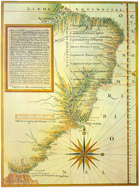
Portuguese map (1574) by Luís
Teixeira,
showing the location of the hereditary captaincies of Brazil.
Likewise in the second half of the 18th century
there was a systematic policy of regional occupation through
the constitution of a network of cities or villages named after
cities back in Portugal: Chaves, Abrantes, Braganca, Obidos,
Belmonte. Jesuit settlements with their indigenous names lost
not only the Jesuits when the Societas Jesu was disbanded in
Brazil in 1767 but also their names, as they were rebaptised
( Nova Almeida, Vila Flor, Trancoso are examples),
Nowadays the occurrence of Tupi toponyms in
the various Brazilian states does not necessarily reflect the
influence of the indigenous population or of Tupi-speaking explorers
in the naming processes. It only shows that these names have
Tupi etymology, but in fact they may have been given by non-Tupi
speaking officials. Bustamante (2005) has shown that preference
for providing administrative territorial units with names of
Tupi origin was stimulated in the period 1930-1945 when Getúlio
Vargas was president, and a broad toponymic change was promoted
due to the so-called Geographical Law of Estado Novo (New State).
Aiming at the systemic ordering of the Brazilian administrative
and territorial division, the federal government approved this
Law in 1938. Besides prohibiting the repetition of names of
towns and districts, it recommended "the preference to
adopt regional names of the regional native language or related
to historical facts of the region in case of replacement of
toponyms" (IBGE, 1943, p. 436).
More recently, this tendency is still
alive; it is for instance visible in a recommendation included
in the laws of the National System of Nature Conservation Unit
(Law n. 9.985, dated 18th July 2000 and Decree n. 4.340, dated
22nd August 2002) to give preference to names of Indian ancestors
in the choice for the designation of federal conservation units.
According to article 3, "the denomination of each conservation
unit should be based, preferably, on its most significant natural
feature, or on its oldest denomination, giving priority, in
this case, to the designations of the Indian ancestors"
(2004, p.37).
|
  |
|
|
|
|