After the name information has been gathered in the field, this
information has to be stored and prepared for dissemination.
Several methods exist for storing the data, from the paper cards
being an old-fashioned but proved media, to the advanced digital
techniques using databases.
For storage of names information
in a digital format, one has several options: Text file such
as Microsoft Word or spreadsheet such as Microsoft Excel are
easy to handle, but the methods have very limited capabilities
in digital processing. Databases such as Microsoft Access are
more complicated, but the data can be connected with other databases
such as GIS repositories, and it can be processed in many ways.
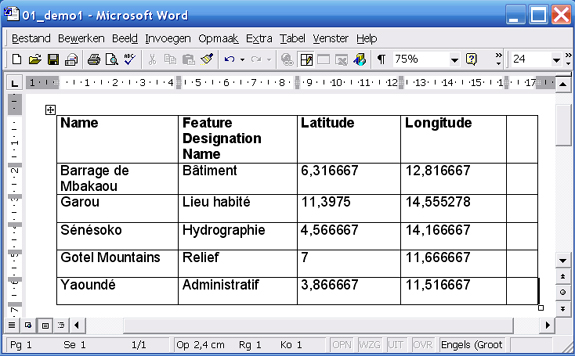
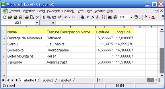
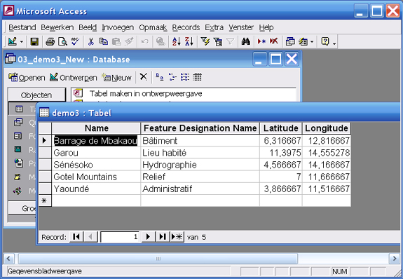
Small demo tables in MS Word, MS Excel and MS Access (01_demo1.doc, 02_demo2.xls, 03_demo3.mdb) are part of the ZIP-Archive ‘S15_demotables.zip and can be downloaded here, or see below for previews.
It has to be considered that for
proprietary database software solutions high license costs might
be needed whereas open source software products such as MySQL,
PostGreSQL/PostGIS are free, but some maintenance and updating
skills are required.
When creating a database, one has
to consider very carefully the layout and the structure of the
database tables. Usually, the core table will hold one row for
each geographical name. The definition of columns (fields) may
vary considerably from country to country, but there are general
rules that apply to most databases of geographical names. Typical
fields associated with a geographical name are feature type,
coordinates, variant names, textual description, source of the
name information and status of the name.
After the database tables have
been defined and data from the field collection has been typed
in, there are many options to process the data.
Examples in practice:
To search for geographical names several web services and applications can be used. Some of them are listed below:
This project combines geographical names from the National Mapping and Cadastral Agencies (NMCAs) across Europe to create a unique service and data set. It is now being implemented by EuroGeographics (the European association of NMCAs) and its partners for an increasing number of countries in Europe.
link: http://www.eurogeographics.org/eurogeonames
link: http://www.eurogeonames.com:8080/RefAppl3/ReferenceApplication/ReferenceApplication.html
The geographical names database of the United Nations Group of Experts on Geographical Names (UNGEGN) supports multilingual and multiscriptual geo-referenced geographical names. Through the web, database users can access short and full names of countries (192 UN member states), their capitals, and the major cities (population over 100,000) for many countries. Authoritative city endonyms are provided mainly by national name authorities and sound files are being added to assist users with pronunciation.
link: http://unstats.un.org/unsd/geoinfo/geonames/Default.aspx
- GeoNym (African gazetteer application)
This African GeoNyms gazetteer application is a free tool to create names databases, particularly within the context of an African spatial data infrastructure.
This project as an initiative of the UN Economic Commission for Africa (UNECA) provides African Countries with open source solution for capturing and validating geographical names (toponyms).
link: http://geoinfo.uneca.org/geonyms
- Asia South East Pacific South West Division gazetteer
In 2009 CGNA, on behalf of UNGEGN, completed the production of a fully revised regional map and gazetteer of Asia South East, Pacific South West.
link: http://www.icsm.gov.au/cgna/ungegn.html
- Geonames.org
The GeoNames geographical database is available for download, through a number of webservices and a daily database export free of charge under a creative commons attribution license. GeoNames is integrating worldwide geographical data such as names of places in various languages, elevation, population and others from various sources.
link: http://www.geonames.org/
- Gazetteer of Australia Place Name Search
The Gazetteer provides information on the location and spelling of more than 332.000 geographical names across Australia as at January 2011. Copyright of the Gazetteer data resides with the relevant state, territory and Australian Government agencies which are custodians of the data. The Gazetteer of Australia 2010 release is available for download.
link: http://www.ga.gov.au/place-name/
REFERENCES
- [ISO, 2001] ISO/DIS 19112, Geographic information – Spatial referencing by geographic identifiers (2001)
- [UNCSGN, 2002] United Nations Resolution VIII/6 (2002), Integration of Geographical Names Data into National and Regional Spatial Data Infrastructures, Eighth United Nations Conference on the Standardization of Geographical Names (2002)
- [OGC, 2005] Open Geospatial Consortium (OGC), OGC Web Services Common Specification (2005)
- [INSPIRE, 2007] Directive 2007/2/EC of the European Parliament and of the Council of 14 March 2007, establishing an infrastructure for spatial information in the European Community (INSPIRE), Brussels, 25.4.2007, Official Journal of the European Union (L108/1), (2007)
- [INSPIRE, 2009] INSPIRE Data Specification on Geographical Names – Guidelines (2009)
- [OGC, 2012] Open Geospatial Consortium (OGC), Gazetteer Service - Application Profile of the Web Feature Service Best Practice, OGC 11-122r1 (2012)
- [UNCSGN, 2012-1] E/CONF.101/57 The Four Faces of Toponymic Gazetteers, Tenth United Nations Conference on the Standardization of Geographical Names
- [UNCSGN, 2012-2] E/CONF.101/55 UNSDI Gazetteer Framework for Social Protection in Indonesia, Tenth United Nations Conference on the Standardization of Geographical Names