Planet and Google are ready to help the United Nations in the data work behind the 2030 Agenda for Sustainable Development
Ronald Jansen · 27 September 2019The 2030 Agenda for Sustainable Development was adopted in 2015 by all Heads of States. It provides a shared blueprint for peace and prosperity for people and the planet, now and into the future. At its heart are the 17 Sustainable Development Goals (SDGs), which are an urgent call for action by all countries - developed and developing - in a global partnership. They recognize that ending poverty and other deprivations must go hand-in-hand with strategies that improve health and education, reduce inequality, and spur economic growth - all while tackling climate change and working to preserve our oceans and forests.
To achieve the goals and targets by 2030, we need to know if we are on the right track and need to know in which areas we have to speed up our efforts. The global community of official statistics was explicitly made responsible for assuring relevant data to monitor progress. Not surprisingly, it proves to be an enormous challenge to provide timely and frequent data for monitoring change on the SDG indicators, preferably also at local levels of all societies. In this regard, Ms. Amina Mohamed, the UN Deputy Secretary-General, emphasized in her video message to our 5th international conference on Big Data in Kigali in May of this year that "Quality, relevant and timely data are essential to drive policies and programs, whether it be in our efforts to create decent work for all, monitoring environmental degradation, containing the spread of the Ebola virus or improving the living conditions in our urban areas. We need not only good data, but also real-time data."
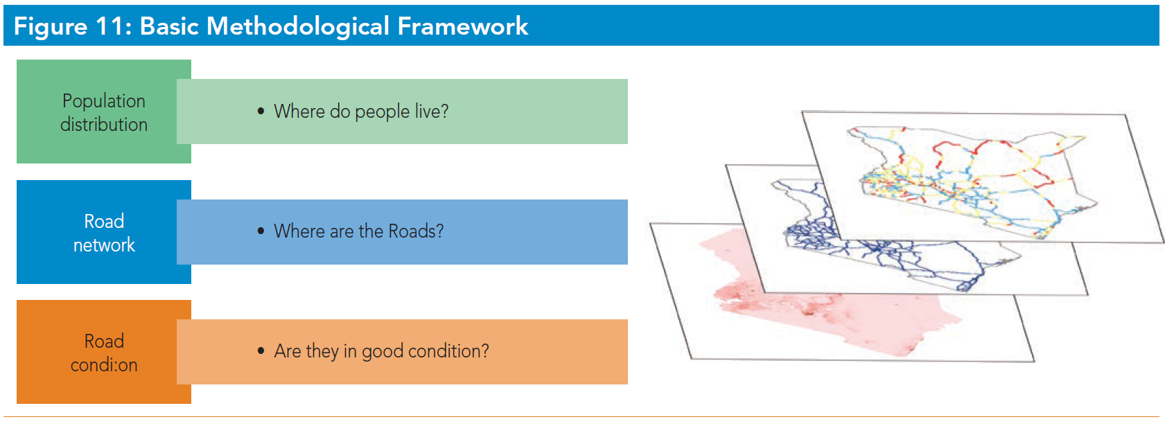
Take for example SDG indicator 9.1.1 on the proportion of the rural population who live within 2 km of an all-season road. You could present this as a proportion at the national level, but what policy makers and the society in general are really interested in is to know in which parts of the country improvements of infrastructure are most urgently needed. Access to all-seasons roads is critically important, as it helps in getting access to work and to services, which are major factors in reducing poverty and improving health.
From "Measuring rural access: using new technologies" (DFID, World Bank and Recap, 2016)
To measure indicator 9.1.1 you need a combination of data sources, such as data on population distribution and high resolution satellite data (or other remote sensing data). In addition, you need to develop algorithms to detect housing, to detect roads and their condition, measure elevation and physical obstacles (such as rivers), etc; all as inputs to methods for calculation of access of rural population to an all-season road. High-resolution satellite imagery would allow for collecting a variety of information on road surface in a highly systematic way. This option has the advantage of consistency and objectivity. Through use of high-resolution satellite data combined with well-trained algorithms it becomes feasible to locate some road links that are not shown on an official map and identify surface type. With higher resolution satellite imagery, some identification of the condition of unpaved roads may be possible.
Partnering with Planet and Google Earth Engine
Over the last 5 years, we have explored use of Big Data, recognized the potential of it in the production of the SDG indicators and recognized at the same time that we have to partner with private sector, academia and civil society institutes to be able to use Big Data, such as satellite imagery or mobile phone positioning data. Recently, in 2018, we put into place the so-called UN Global Platform, which is a cloud-based collaborative research and development environment for the global statistical community and all its stakeholder groups. Its platform organization is based on networking and marketplace principles, which facilitates the exchange, development and sharing of data, methods, tools and expertise, and accelerates data innovation.
On this platform we are using Landsat and Sentinel data to experiment with agricultural crop identification, measuring fresh water extent and some other applications. However, we need partners like Planet and Google to deliver at scale. Planet is a company based in Silicon Valley, which started less than 10 years ago with just a few satellites and has grown to a market leader with more than 100 satellites, with which it can provide imageries of every place on earth, on every day of the week. Planet can provide high-resolution (3 meter or even 80 cm) images at high frequency, which could potentially help the statistical community on many fronts: for agricultural crop yield estimates, for environmental degradation or detection of for urban sprawl. We are in active discussion with Planet to find the best solution for a partnership, which will help the statistical community in its quest for detailed and timely SDG indicators and will be fully in line with Planet's mission of "using space to help life on earth".
"Big data from satellites and other sources can accelerate progress on the SDGs, but only if it can be distilled into timely, actionable insights"
Rebecca Moore, Director, Google Earth
Google is a strategic partner of Planet and the tools of Google Earth Engine work therefore very well on Planet data. Our community has been working with the Earth Engine team most notably in efforts to measure the extent of fresh water in every country of the world.
On 25 September 2019, Google Earth Engine has officially teamed up with the Global Partnership on Sustainable Development Data, an initiative which is supported by the United Nations. They have entered into an MOU focused on collaborating across platforms on earth observations for the SDGs. "Big data from satellites and other sources can accelerate progress on the SDGs, but only if it can be distilled into timely, actionable insights," said Rebecca Moore, Director, Google Earth. "We're excited to join the Global Partnership for Sustainable Development Data today and contribute Google's advanced geospatial capabilities and interoperable cloud technologies to help unlock those insights and catalyze solutions."
Data-for-Now initiative
The Data-for-Now initiative aims to increase the use of robust methods and tools that improve the timeliness, coverage, and quality of SDG data through collaboration and partnership, technical and capacity support, and information sharing. The Global Partnership for Sustainable Development Data, the United Nations Statistics Division, the World Bank, and the Thematic Research Network on Data and Statistics (TReNDS) at the Sustainable Development Solutions Network, working with governments and partners from across the United Nations system, multilateral organizations, the private sector, academic networks, and civil society have launched on the 25th of September 2019 this ambitious new collaboration. The program will build a community of data users, leaders, and innovators, partnering in new ways to deliver more robust and timely data that will help us achieve the SDGs.
The initiative will work with 8 initial country partners (Ghana, Senegal, Colombia, Paraguay, Bangladesh, Mongolia, Nepal, Rwanda) to identify key data that the governments need in real time to make better-informed decisions. The countries' data requirement might include poverty rates, population growth, agricultural crop production, deforestation, biodiversity loss, urban development, economic performance and many more. Data-for-Now will use the UN Global Platform and its community to execute the pilot projects and provide skills, training, equipment and methodologies. It will engage local experts, in universities and centers across these countries, to build more local capacity, whilst engaging private companies such as Google, Esri, Facebook and many more, to provide services to help deliver in a short period of time.

Ronald Jansen
Ronald Jansen is Assistant Director of the United Nations Statistics Division in New York. He is responsible for the Division's work on data innovation and on capacity development strategies. This includes leading the intergovernmental processes for innovation of official statistics and implementing the capacity development pillar of the Cape Town Global Action Plan in support of the monitoring of the 2030 agenda for sustainable development.