|
3. Plane rectangular coordinate systems |
||
|
Rectangular coordinate systems for national use, also called national grid systems, are always based on a particular map projection. A map projection by itself isn't enough to define a national grid system. One has to define e.g.:
The above points A) and B) are described in seperate paragraphs on the following pages. The most widely used grid system is
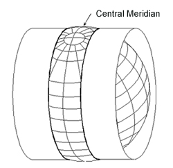
the so-called UTM system. UTM
stands for Universal Tranversal Mercator, this being the name
of the cartographic projection on which it is based. The UTM
system is designed to cover the whole world (excluding the
Artic and Antartic regions). It is a version of the Transverse
Mercator projection, see figure below.
Click here for enlargement and original file (location / source).
|
||
|
|
|
Home | Self study : Reference sytems | Contents | Intro | 1.Graticule / topographic grid | 2.Projection Systems (a/b/c/d) | 3.Plane rectangular coordinate systems (a/b) | 4.Coordinate transfor-mations | 5.Satellite-based positioning (a/b) |