|
|
|
|
3. Plane rectangular coordinate systems - A) the
ellipsoid / geoid
|
|
|
Up till now we have regarded the Earth
as a perfect sphere, but it is not. It is not only flattened
on the poles, but its surface is also irregular, and that is
why we call it a geoid. In order to represent it with the least
possible distortion, we try to project this geoid on an ellipsoid
that fits our area best. There are both geoids that fit a particular
part of the world best and geoids that fit the geoid best globally.
For GPS measurements we opt for a global system.

Source: Knippers, 2010
In words, Wiki
defines an (reference) ellipsoid as:
"... a mathematically-defined
surface that approximates the geoid, the truer figure of the
Earth, or other planetary body. Because of their relative
simplicity, reference ellipsoids are used as a preferred surface
on which geodetic network computations are performed and point
coordinates such as latitude, longitude, and elevation are
defined.....
...... Mathematically, a reference
ellipsoid is usually an oblate (flattened) spheroid with two
different axes: An equatorial radius (the semi-major axis
 ),
and a polar radius (the semi-minor axis ),
and a polar radius (the semi-minor axis  )". )".
See image below for typical parameters for an
ellipsoid.

Source: Knippers, 2010
The Geoid is used to describe heights.

Source: Knippers, 2010
In order to establish the Geoid as reference for heights, the
ocean’s water level is registered at coastal places over
several years using tide gauges (mareographs). Averaging the
registrations largely eliminates variations of the sea level
with time. The resulting water level represents an approximation
to the Geoid and is called the mean sea level.

Source:
Knippers, 2010
The geoidal undulation (N) is the
separation between the geoid and an ellipsoid. It varies globally
between ±110 m.
| There are also several
realizations of local mean sea levels (also
called
local vertical datums) in the world.
They are parallel to the Geoid but offset by up to a couple
of meters. This offset is due to local phenomena such as
ocean currents, tides, coastal winds, water temperature
and salinity at the location of the tide-gauge.Care must
be taken when using heights from another local vertical
datum. This might be the case in the border area of adjacent
nations. |
Countries establish a horizontal (or geodetic) datum (see next
paragraph), which is an ellipsoid with a fixed position, so
that the ellipsoid best fits the surface of the area of interest
(the country)

Source: Knippers, 2002
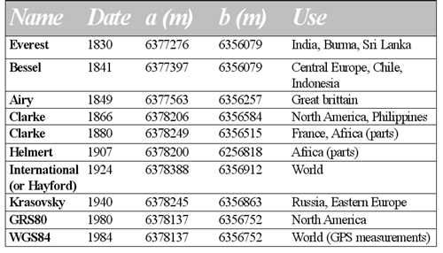
Commonly used ellipsoids are:
In the next
paragraph more information is given on geodetic datums.
|
  |
|
|
|
|
|
|
|