Sources:
Center for International Earth Science Information Network (CIESIN), Columbia University. Low Elevation Coastal Zone (LECZ) Urban-Rural Estimates, Global Rural-Urban Mapping Project (GRUMP), Alpha Version. Palisades, NY: Socioeconomic Data and Applications Center (SEDAC), Columbia University. Available at http://sedac.ciesin.columbia.edu/gpw/lecz. (2009).
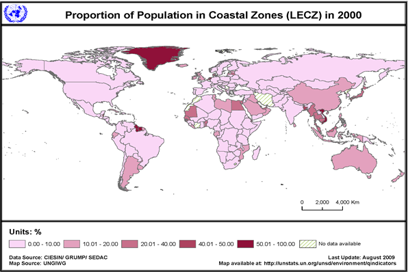
Proportions calculated by UNSD Environment Statistics Section
Footnotes:
- Landlocked
- Flagged by source for possible errors; some of the countries/areas are represented as having no urban areas (settlements with a population of 5000 or larger). Other countries were flagged because of missing data or issues needing investigation.
Definitions & Technical notes:
The proportions of populations (urban, rural and total) in low elevation coastal zones (LECZ) are calculated for each country or area by UNSD using total and LECZ population figures available from CIESIN/SEDAC.
Low Elevation Coastal Zone (LECZ) is defined in this table as the contiguous area along the coast that is less than 10 metres above sea level.
Country-level estimates of urban, rural and total population and land area in a low elevation coastal zone (LECZ) were generated globally using Global Rural-Urban Mapping Project (GRUMP) alpha population and land area data products and a Digital Elevation Model (DEM) derived from Shuttle Radar Topographic Mission (SRTM) remote sensing data.
The zone was derived from the DEM by selecting all land contiguous with the coast that was 10 metres or less in elevation. Zonal statistics were generated for urban, rural and total population and land area for the country as a whole and within the LECZ.
Grids for determining population and LECZ are at 1 km (30 arc-second) resolution. The SRTM dataset used came from ISciences; the GRUMP data were developed by CIESIN.
For more information on the methodology see:
McGranahan, G., D. Balk and B. Anderson. 2007. The rising tide: assessing the risks of climate change and human settlements in low elevation coastal zones. Environment & Urbanization 19(1): 17-37 (2007). International Institute for Environment and Development (IIED). http://eau.sagepub.com/cgi/content/abstract/19/1/17
Data Quality:
The spatial detail of census data varied greatly between countries and 1km resolution was considered the highest resolution that could be supported globally. The SRTM data utilized was at a resolution of 1km to facilitate a 1 to 1 spatial match with the population data. By degrading the resolution of the SRTM data to 1km, the estimates shown likely underestimate the population counts in the zone. The 10 metre elevation ceiling was chosen in part because of the SRTM data precision globally.
For more information visit: CIESIN/SEDAC (http://sedac.ciesin.columbia.edu/gpw/lecz).
|