Sources:
UNSD Millennium Development Goals Indicators database (see http://mdgs.un.org/unsd/mdg/Data.aspx).
Definitions & Technical notes:
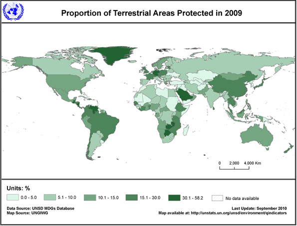
The definition of a “protected area”, as adopted by the International Union for Conservation of Nature (IUCN), is “an area of land and/or sea especially dedicated to the protection and maintenance of biological diversity, and of natural and associated cultural resources, and managed through legal or other effective means”. (IUCN 1994. Guidelines for Protected Areas Management Categories. IUCN; Gland; Switzerland and Cambridge; UK)
Proportions are calculated as the total terrestrial protected area extent divided by the total country (surface) area (includes total land area and inland waters).
Protected areas increase with time and are not deleted from subsequent years. Only protected areas that are “nationally designated” are included in this indicator. The status "designated" is attributed to a protected area when the authority that corresponds, according to national legislation or common practice (e.g. by means of an executive decree), officially endorses a document of designation. The designation must be for conservation of biodiversity, not single species and not fortuitous de facto protection arising because of some other activity (e.g. military). Hence, a number of United States Marine Managed Areas as well as permanent fisheries closures are excluded.
Data are adjusted to account for transboundary protected areas (protected areas that transcend international boundaries) to ensure that the appropriate area/extent from the total area for that site is attributed to the country in which it is contained. Similar adjustments have been made where a protected area transcends both marine and terrestrial environments.
The size of the protected area (its “extent”) is the officially documented total area provided by the national authority or as listed by the World Database on Protected Areas and may be generated from spatial (GIS) boundary data (see source for details). Many protected areas can contain proportions of both the marine and terrestrial environment, and the size of the protected area extent that falls into each environment is not always available. The table also includes some protected areas for which the year (date of establishment/designation) is unavailable.
Where the documented total area is unavailable the following rules have been applied:
1. Where the documented total area of the site is unavailable but the spatial (GIS) boundary is present in the WDPA, the total area calculated from the GIS will be used; and
2. Where spatial (GIS) boundaries and the documented area from national sources are unavailable, UNEP-WCMC works with the collaborating NGOs to help source this information. Where no additional information, either from national sources or NGOs, can be found then the site is excluded from the statistics.
If no update is received for a given year, the total number and size of the protected area is assumed to be equal to the previous year’s values.
Data Quality:
The World Database on Protected Areas (WDPA) is compiled from multiple sources and is the most comprehensive global dataset on marine and terrestrial protected areas available. It is a joint project of UNEP-WCMC and the IUCN World Commission on Protected Areas working with governments and collaborating non-governmental organizations (NGOs).
A major source of information is through the UN List process, which takes place every 4-5 years. As part of this process, key stakeholders review and provide information to assist in the compilation of the UN List of Protected areas. In the intervening period between UN Lists, UNEP-WCMC works closely with national authorities and NGOs to continually update the WDPA, as new information becomes available.
There are known data and knowledge gaps that exist in some countries/regions due to difficulties in: reporting capacities; measuring the proportion of a protected area within the terrestrial and/or marine environment; and determining whether a site conforms to the IUCN definition of a protected area/MPA.
The list of protected areas does not provide information on non-designated protected areas that may also be important for conserving biodiversity. Further, the spatial extent of nationally designated protected areas does not indicate how well managed the area is in practice, nor does it confirm that protection measures are actually enforced for the entire extent. However, UNEP-WCMC and IUCN have defined and monitor categorizes of nationally designated protected areas in order to improve data quality.
For more information visit the World Database on Protected Areas (WDPA) website at: www.wdpa.org/.
|